 |
|
|
|
|
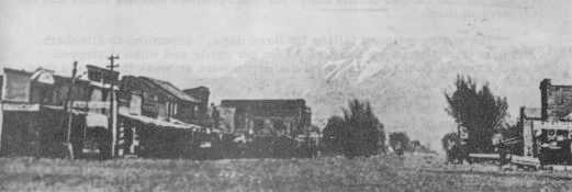
IIBROWNSVILLE -1847-1851
|
Website Link Index | ||||||||||||
|
Orson Pratt Brown's Home Town
|
|
Some historians believe that the county name of "Weber" was a corruption of Pauline "Weaver" whom legend described as an old trapper who wrote so poorly that historians transcribed his name incorrectly. According to Dr. David E. Miller, a native of Syracuse, Davis County, Utah, and professor of history at the University of Utah: "During the fall and winter of 1824-1825, a brigade of American trappers under the leadership of John H. Weber, followed Bear River from its big bend of present Soda Springs, Idaho, southward into Cache Valley. Winter camp was established near the present site of Franklin, Idaho. With the arrival of spring 1825, Weber and his men followed Bear River to the points of its discharge into great Salt Lake, then turned to the South, exploring and trapping the various streams that flowed westward out of the Wasatch Range. During that spring, Weber and his men reached, explored, and trapped Weber River - named for John H. Weber, leader of the brigade." Dr. Miller stated, "Obviously, Weber County and Weber College took their names from the same source."
Early Settlement
|
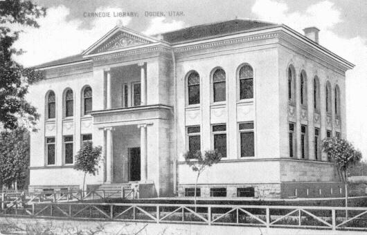
Ogden's Carnegie Library 1902-1970 |
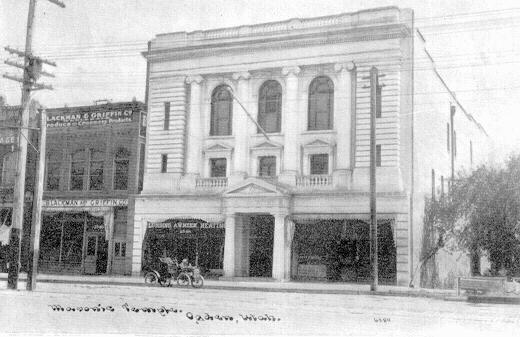 Ogden's Masonic Hall 1906 to present |
 |
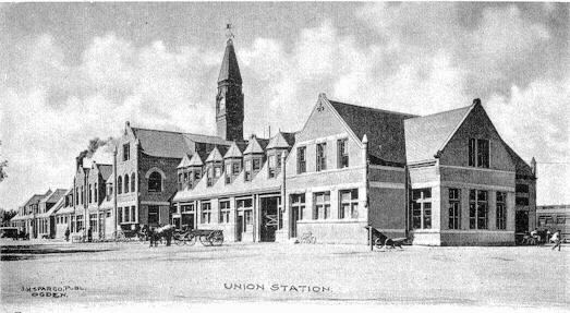 Ogden Union Station 1888 - 1923 |

Quoted from the Utah Historical Quarterly, Vol. 1, 1928. Page 91.
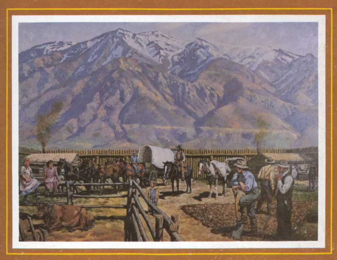
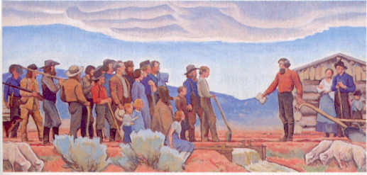
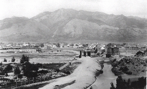
Brown's Fort. Miles Goodyear obtained a grant of land from the Mexican Government in 1841. Under this he claimed the tract of land beginning at Weber Canyon, following the base of the mountains north to the Hot Springs, thence west to Great Salt Lake along the shore to a point opposite Weber Canyon and thence back to the beginning. This land extended about eight miles north and south and from the base of the mountains east to the shores of Salt Lake on the west. Goodyear built a picket fort and a few log houses on land now occupied by the Union Pacific Railroad Company in Ogden. Goodyear was living at the fort with a few mountaineers and half-breed Indians when Captain James Brown of the Mormon Battalion arrived. Captain Brown purchased all of his rights for the sum of $3,000.00. Captain Brown established a colony at Ogden in the Spring of 1848 and located in this section. The fort built by Goodyear and later occupied by the Mormons was renamed Brown's Fort. Farr's Fort, Bingham Fort, Mound Fort and Kingdom's Fort were in the same vicinity, now Ogden Utah.
In 1983 Betty Cook wrote: "Weber County, one of the first counties, formed in 1850, consists of 549 square miles in the northern part of Utah. North of Weber County is Cache County; north and west is Box Elder County; south are Davis and Morgan counties; and east is Rich County. Although Weber County is the second smallest county is size in the state of Utah (Davis County is the smallest), it is the fourth largest in population. Salt Lake County has the greatest number of residents; Utah County is second; Davis County is third; and Weber County is next, with a population almost as large as that of Davis County.
"The 1980 census reports a population of 144,616 for Weber County. Of that figure, 135,054 were white, 2,225 were Black, 736 were Indian: 1,415 were Asian, and 5,186 were of other races. The figure given for those of Spanish origin was 8,570, which is included in the number of white residents in the county.
There is disagreement among historians about the origin of the name Weber. One explanation is that the county was named for the Weber River, which was named for John H. Weber, one of the American trappers who entered Great Salt Lake Valley in 1825 and who was killed by Indians near the river a few years later. A second story is that the river was named for Pauline Weaver, also an early trapper, who was a frontiersman in Arizona. The river is called "Weaver's Fork" by some of the early writers of material about this area.
Most of the residents of Weber County live in Ogden, which is the county seat, and in the rural communities around the city. Ogden has an elevation of 4,370 feet. The climate is stimulating with low humidity. Average rainfall totals 17.92 inches a year. The average high summer temperature is 91.8 degrees; the average low winter temperature is 20.4 degrees.
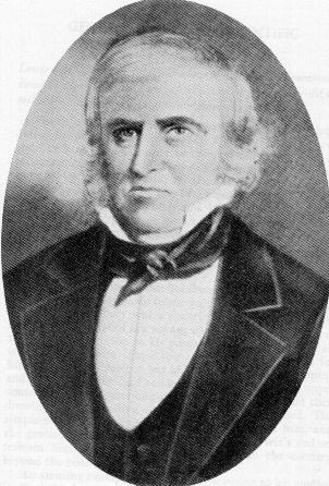
Peter Skene Ogden 1794-1854
Ogden was named for Peter Skene Ogden, a representative of the Hudson Bay Fur Company, who trapped in the region about 1826. How the renaming of Brownsville came about is unknown.
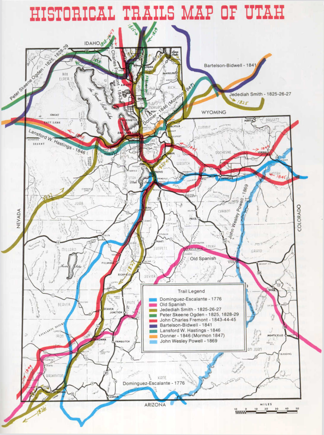
[Peter Skene Ogden, born in 1794, was an experienced trapper and mountain man who remained with the Hudson's Bay Company after its 1821 merger with the Northwest Fur Company. In November 1824 Ogden was appointed leader of the Snake River Country Expeditions by John McLoughlin, and he was instructed to continue the British policy of creating a "fur desert" between American territory and the southern Columbia River drainage to discourage American trappers from coming into the area.
Ogden, with a brigade of 131, pushed south from Flathead House toward Utah in December 1824. Accompanying the British was a small group of Americans directed by Jedediah Smith. By April the expedition had reached the Bear River, where the two outfits parted company. Ogden continued south along the Bear River to Cub Creek in present Cache Valley, where he learned from Snake Indians that Americans (John H. Weber's brigade) had already trapped the area. The British continued south through present-day Smithfield, Logan, Hyrum, and into the Huntsville area via Paradise Canyon. After trapping the Ogden Valley region, Ogden took his brigade across the divide south of Huntsville and established his southernmost camp near present Mountain Green. Records seem to indicate that Ogden himself did not enter the area of the present-day city which now bears his name, nor is it positively known if he even saw the Great Salt Lake at this time. However, men of his brigade did return from their trapping with accounts of these areas, and it is quite possible that Ogden did observe them.
While encamped at Mountain Green, Ogden's company was visited by two groups of trappers. The first was led by Etienne Provost, and the second was a group of "Ashley Men" from John Weber's brigade led by Johnson Gardner. Discussion between Ogden and Gardner regarding ownership of the territory escalated into a heated exchange. Ironically, both parties were trespassing on Mexican territory. Gardner enticed twenty-three of Ogden's men to defect to the American camp, bringing more than 700 pelts with them. Fearful of additional desertion and losses, and also to avoid possible diplomatic repercussions, Ogden gathered the remainder of his brigade and retraced his steps to Flathead Post. Undoubtedly, had Ogden not been forced to withdraw, his journals would have provided the earliest and most complete account of what became the Utah Territory.
Ogden continued to lead Hudson's Bay Company brigades; however, not until his 1828-29 expedition did he again enter the Utah area. This journey brought Ogden south from Fort Nez Perce to what trappers called "Ogden's" or "Mary's" River, later named the Humbolt by John C. Frémont. Pushing east, Ogden's brigade proceeded to present-day Lucin, Utah, then north along the east side of the Grouse Creek Range. The expedition then proceeded eastward across Park Valley and camped near Ten Mile Spring. Ogden indicates that at this spring he had his first view of the Great Salt Lake; whether this meant his first view during this expedition or his first time ever is uncertain. After observing the lake, Ogden continued north toward Soda Springs, then south along the Bear River through Cache Valley to where the Malad River joins the Bear. After trapping the area, Ogden's brigade returned to Ten Mile Spring, skirting the north end of the Great Salt Lake and retracing their route out of Utah.
Ogden's impact upon the fur trade was immense; however, after his 1828-29 expedition he never again entered Utah. He did remain active in the Hudson's Bay Company until a few months prior to his death in 1854. http://www.onlineutah.com/historypeterskeneogden.shtml]
Another trapper, Miles Morris Goodyear, was granted "all the land between the mountain and the lake" by the Mexican government which claimed the territory at that time. In 1841 Goodyear built a log cabin in the area, the first permanent home in Utah [Captain James Brown of the Mormon Battalion purchased the Mexican land grant property and cabin in January 1847], the cabin now stands next to the Pioneer Hall Museum on Ogden's Temple Square. The area became known as Brownsville.
Brigham Young, Mormon leader, led a group from Salt Lake City to the area around Weber in 1850 to lay out the city which was incorporated as Ogden in 1861 [February 6, 1851]. Now the city is a bustling municipality, the center of the entire marketing area. Ogden is also the location of Weber State College, a four-year college where about 10,000 students were enrolled in 1979.
[Where did Weber come from? A canyon, a county, and a river share this name. Some people claim the name comes from a Dutch sea captain, John H. Weber, a trapper with General Ashley who was killed by Indians in 1825 near the river shortly after his arrival to the area in 1823. Others believe the area was named for Pauline Weaver, an Arizona frontiersman, who was in the area].
Weber County ranks seventh in the state in the economic value of its agricultural products, with a figure reported in 1979 as $26,346,000, about $2,000,000 lower than it had been five years earlier. Agricultural products are beet sugar, cereals, flour and grain products, dairy and poultry products, all from Ogden. Meat products come from Roy and Ogden: and canned fruits from Roy.
The Government ranks first as the employer with the largest number of workers. The United States Air Force, realizing the convenience of the location of Weber County for dealing with the gathering of supplies, maintaining equipment, ease of movement of personnel, providing facilities, and other related concerns, established Hill Air Force Base in the Weber County Area. Over 15,000 civilians and 3,000 military people are employed at the base. The Internal Revenue Service, with 3,000 employees at Ogden, provides tax services and processes tax forms for all western states except California, as well as states in the mid-west.
The wholesale and retail trade is second in the number of employees. Service-related and miscellaneous nonagricultural work is third, with manufacturing running a close fourth. There are 160 manufacturing plants in Weber County. Some of the products are pharmaceuticals, lingerie, transportation equipment, prefab homes, zirconium alloy, and chemicals. The natural resources that come from the forests of Weber County are made into wood products, millwork products, and prefab buildings in Ogden. The principal products that come from mining are potash, industrial chemicals, sand and gravel, also produced in Ogden.
Ogden was formerly the location of the Browning Arms Company which has moved its operations to Mountain Green in Morgan County. However, the John M. Browning Armory and Firearm Museum is still located in Ogden. Browning's shop and many of his machine guns, rifles, and pistols are on display there.
John Moses Browning was born in Ogden on January 21, 1855. His father, Johnathan Browning, was a gunsmith. In 1879 John, at the age of 23, invented his first rifle. He sold the rights to his single shot rifle to the Winchester Company, but soon founded the Browning Brothers' Sporting Goods Company in Ogden, which later became the Browning Arms Company. He worked on an improved rifle in 1884 and devised a repeating rifle, then automatics and machine guns. He enriched the realm of repeating small arms. His flourishing firm developed repeating rifles of various calibers and gauges. His firm became known as the largest arms factory between Omaha and the Pacific.
John Moses Browning died in Herstal, Belgium, November 26, 1926. The Browning Arms Executive Offices and Research & Development Department remained in Ogden until 1965 when the move was made to new facilities in Mountain Green.
Another person of note who should be mentioned here is Herbert B. Maw, who was Utah's eighth Governor, serving from 1941-1949. He was born in Ogden March 11, 1883, and attended elementary school there. He graduated from the University of Utah, received a doctorate from Northwestern University, was in the Army Air Corps, later turning to teaching in high school and then at the University of Utah. He was in the Utah Senate, then became Governor of the State. After his term in office, he remained in Salt Lake City to practice law.
Still another noted person from this area was Fawn McKay Brodie, author of numerous books including THE DEVIL DRIVES, A LIFE OF SIR RICHARD BURTON; NO MAN KNOWS MY HISTORY, THE LIFE OF JOSEPH SMITH THE MORMON PROPHET; THOMAS JEFFERSON, AN INTIMATE HISTORY; and RICHARD NIXON, THE CHILD AND THE MAN which was published posthumously, was born September 15, 1915, in Ogden and grew up in Huntsville. She was the daughter of Thomas E.McKay and Fawn Brimhall McKay. She lived in many states and died in California January 10, 1981.
Another author, Bernard De Voto, was born in Ogden January 11, 1897. He was considered an authority on Mark Twain and wrote many articles and stories about him. He was editor of the SATURDAY REVIEW OF LITERATURE and wrote a column in HARPER'S MAGAZINE Among his books are THE CROOKED MILE, MARK TWAIN'S AMERICA, ACROSS THE WIDE MISSOURI, which won the Pulitzer Prize for history in 1948, and THE YEAR OF DECISION He died in New York November 13, 1955•
The musical entertainment family, the Osmonds of Utah, can call Weber County home, having grown up in Ogden and Huntsville. Donny and Marie Osmond became stars on television and the idols of many people across the country. They built their own production studio in Utah County which attracts many visitors.
As for places to visit for recreation in Weber County, part of the "Golden Spike Empire" travel region, there is the Wasatch National Forest, which is only partly in Weber County, and, while there is no national park in the county, there are numerous county and municipal parks. Antelope Island, approved in 1978 as a state park and recreation site, is located in nearby Davis County and attracts many people to Weber County.
There are also Ogden Bay and Great Salt Lake to visit. Nordic Valley, Snowbasin, and Ogden's newest resort, Powder Mountain, are popular sports areas for skilers, campers, and picnickers. Elk and deer hunting are excellent in the forests of Weber County. Hiking and climbing Mt. Ogden are enjoyed by many who come to the area.
Weber County has a daily newspaper, THE OGDEN STANDARD EXAMINER, published in Ogden. Weekly newspapers are THE SUN CHRONICLE and THE CLEARFIELD COURIER, both published in Roy. There are several radio broadcasting stations in Weber County: KLO,KANN, KSVN, KVOG, KJQ and KZAN, all in Ogden; and KQPD, in Roy. The county is served by television stations KUTV-2, KTVX-4, KSL-5, KUED-7, KSTU-20 (UHF), all of Salt Lake City; and KBYU-11, Provo. Cable television is also available in the county.
Ogden Municipal airport is in Weber County." End of Betty R. Cook 1983 description.
Sources:
PAF - Archer files = Mexico > Miles Morris Goodyear > Captain James Brown
Utah Historical Quarterly, Vol. 1, Number 3, July 1928, Room 131, State Capitol, Salt Lake City, Utah. Page 91.
"Here Are the Counties of Utah" by Betty R. Cook, 321 North 300 West, Bountiful, Utah 84010, 1983. Pages 233-239.
"A History of Weber County" Utah Centennial County History Series. Richard C. Roberts and Richard W. Sadler. 1997. Pages 52-64, 74, 84, 88, 99, 132
"Ogden: Junction City" by Richard C. Roberts and Richard W. Sadler. 1985 by Windsor Publications. ISBN: 0-89781-154-2
"Old Goodyear Fort" The Story of Minerva P. Shaw" by Harold H. Jensen, in The Pioneer July 1937, Pages 35-36.
Peter Skene Ogden Journals at http://roxen.xmission.com/~drudy/mtman/html/ogden.html
Copyright 2001 www.OrsonPrattBrown.org
|
|
![]()
To SEARCH THIS SITE: Use the Google.com search engine
Type....site:OrsonPrattBrown.org "TYPE NAME YOU ARE
LOOKING FOR INSIDE PARENTHESIS"...Press ENTER
A list with the search term will appear.
![]() OPB FAMILY BLOG SITE
OPB FAMILY BLOG SITE
... http://orsonprattbrownfamily.blogspot.com/
![]() PERSONAL ANCESTRAL FILE
PERSONAL ANCESTRAL FILE
... Password Access Only
![]() ADDRESS LIST FOR BROWN FAMILY
ADDRESS LIST FOR BROWN FAMILY
... Password Access Only
![]() ORSON PRATT BROWN FAMILY REUNIONS
ORSON PRATT BROWN FAMILY REUNIONS
... Easter 1986 through October 2005
... ARTICLES OF ASSOCIATION - BY-LAWS
COMMENTS AND INPUT ON ARTICLES
... Published December 2007:
![]() "ORSON PRATT BROWN AND HIS FIVE WONDERFUL WIVES VOL. I and II"
"ORSON PRATT BROWN AND HIS FIVE WONDERFUL WIVES VOL. I and II"
![]() By Erold C. Wiscombe
By Erold C. Wiscombe
... Published March 2009:
![]() "CAPTAIN JAMES BROWN AND HIS 13 WIVES"
"CAPTAIN JAMES BROWN AND HIS 13 WIVES"
(unfortunately the publisher incorrectly changed the photo
and spelling of Phebe Abbott Brown Fife's name
after it was proofed by this author)
Researched and Compiled by Erold C. Wiscombe
... Published 2012:
"Finding Refuge in El Paso"
By Fred E. Woods [ISBN: 978-1-4621-1153-4]
Includes O.P Brown's activities as Special Church Agent in El Paso
and the Juarez Stake Relief Committee Minutes of 1912.
...Published 2012:
"Colonia Morelos: Un ejemplo de ética mormona
junto al río Bavispe (1900-1912)"
By Irene Ríos Figueroa [ISBN: 978-607-7775-27-0]
Includes O.P. Brown's works as Bishop of Morelos. Written in Spanish.
...Published 2014:
"The Diaries of Anthony W. Ivins 1875 - 1932"
By Elizabeth Oberdick Anderson [ISBN: 978-156085-226-1]
Mentions O.P. Brown more than 30 times as Ivins' companion.
... To be Published Soon:
![]() "CAPTAIN JAMES BROWN 1801-1863:
"CAPTAIN JAMES BROWN 1801-1863:
![]() TEMPER BY NATURE, TEMPERED BY FAITH"
TEMPER BY NATURE, TEMPERED BY FAITH"
![]() Send Comments and Information to:
Send Comments and Information to:
![]() OrsonPrattBrown@gmail.com
OrsonPrattBrown@gmail.com
... FAMILY GROUP PHOTOS
... FAMILY REUNIONS
... Lily Gonzalez Brown 80th Birthday Party-Reunion
![]() July 14, 2007 in American Fork, Utah
July 14, 2007 in American Fork, Utah
...Gustavo Brown Family Reunion in October 2007
... FAMILY MEMBERS WHO DIED RECENTLY
... NEWS, WEDDINGS, BABIES, MORE
... HELP US IDENTIFY THESE ANCESTORS
![]() Send Additions and Information to:
Send Additions and Information to:
![]() OrsonPrattBrown@gmail.com
OrsonPrattBrown@gmail.com
...... Wives and 35 Children Photo Chart
...... Chronology
...... Photo Gallery of OPB
...... Letters
...... Biographical Sketch of the Life Orson Pratt Brown
...... History of Orson Pratt Brown by Orson P. Brown
...... Journal & Reminiscences of Capt. Orson P. Brown
...... Memories of Orson P. Brown by C. Weiler Brown
...... Orson Pratt Brown by "Hattie" Critchlow Jensen
...... Orson Pratt Brown by Nelle Spilsbury Hatch
...... Orson Pratt Brown by W. Ayrd Macdonald
...... Wives and 29 / 43 Children Photo Chart
...... Captain James Brown's Letters & Journal
...... Brown Family Memorabilia
...... Mormon Battalion 1846-1847
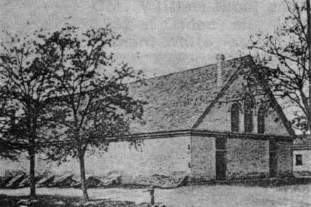
...... Brown's Fort ~ then Brownsville, Utah
...... Chronology of Captain James Brown
- James Brown of Rowan County, N.C. 1757-1823
- Mary Williams of Rowan County, N.C. 1760-1832
- Stephen Joseph Abbott of, PA 1804-1843
- Abigail Smith of Williamson, N.Y. 1806-1889
- John Fife of Tulliallan, Scotland 1807-1874
- Mary Meek Nicol, Carseridge, Scotland 1809-1850
- Martha "Mattie" Diana Romney Brown 1870-1943
![]()
![]()
![]()
- Jane "Jennie" Bodily Galbraith Brown 1879-1944
![]()
![]()
- Elizabeth Graham MacDonald Webb Brown 1874-1904
- Eliza Skousen Brown Abbott Burk 1882-1958
- Angela Maria Gavaldón Brown 1919-1967
![]()
- (Martha) Carrie Brown (child) 1888-1890
- (Martha) Orson Pratt Brown, Jr. (child) 1890-1892
- (Martha) Ray Romney Brown 1892-1945
- (Martha) Clyde Romney Brown 1893-1948
- (Martha) Miles Romney Brown 1897-1974
- (Martha) Dewey B. Brown 1898-1954
- (Martha) Vera Brown Foster Liddell Ray 1901-1975
- (Martha) Anthony Morelos Brown 1904-1970
- (Martha) Phoebe Brown Chido Gardiner 1906-1973
- (Martha) Orson Juarez Brown 1908-1981
- (Jane) Ronald Galbraith Brown 1898-1969
- (Jane) Grant "Duke" Galbraith Brown 1899-1992
- (Jane) Martha Elizabeth Brown Leach Moore 1901-1972
- (Jane) Pratt Orson Galbraith Brown 1905-1960
- (Jane) William Galbraith Brown (child) 1905-1912
- (Jane) Thomas Patrick Porfirio Diaz Brown 1907-1978
- (Jane) Emma Jean Galbraith Brown Hamilton 1909-1980
- (Elizabeth) (New born female) Webb 1893-1893
- (Elizabeth) Elizabeth Webb Brown Jones 1895-1982
- (Elizabeth) Marguerite Webb Brown Shill 1897-1991
- (Elizabeth) Donald MacDonald Brown 1902-1971
- (Elizabeth) James Duncan Brown 1904-1943
- (Eliza) Gwen Skousen Brown Erickson Klein 1903-1991
- (Eliza) Anna Skousen Brown Petrie Encke 1905-2001
- (Eliza) Otis Pratt Skousen Brown 1907-1987
- (Eliza) Orson Erastus Skousen Brown (infant) 1909-1910
- (Eliza) Francisco Madera Skousen Brown 1911-1912
- (Eliza) Elizabeth Skousen Brown Howell 1914-1999
- (Angela) Silvestre Gustavo Brown 1919-
- (Angela) Bertha Erma Elizabeth Brown 1922-1979
- (Angela) Pauly Gabaldón Brown 1924-1998
- (Angela) Aaron Aron Saul Brown 1925
- (Angela) Mary Angela Brown Hayden Green 1927
- (Angela) Heber Jedediah Brown (infant) 1936-1936
- (Angela) Martha Gabaldón Brown Gardner 1940
- Stephen Abbott Brown 1851-1853
- Phoebe Adelaide Brown Snyder 1855-1930
- Cynthia Abigail Fife Layton 1867-1943
- (New born female) Fife 1870-1870
- (Toddler female) Fife 1871-1872
- (Martha Stephens) John Martin Brown 1824-1888
- (Martha Stephens) Alexander Brown 1826-1910
- (Martha Stephens) Jesse Stowell Brown 1828-1905
- (Martha Stephens) Nancy Brown Davis Sanford 1830-1895
- (Martha Stephens) Daniel Brown 1832-1864
- (Martha Stephens) James Moorhead Brown 1834-1924
- (Martha Stephens) William Brown 1836-1904
- (Martha Stephens) Benjamin Franklin Brown 1838-1863
- (Martha Stephens) Moroni Brown 1838-1916
- (Susan Foutz) Alma Foutz Brown (infant) 1842-1842
- (Esther Jones) August Brown (infant) 1843-1843
- (Esther Jones) Augusta Brown (infant) 1843-1843
- (Esther Jones) Amasa Lyman Brown (infant) 1845-1845
- (Esther Jones) Alice D. Brown Leech 1846-1865
- (Esther Jones) Esther Ellen Brown Dee 1849-1893
- (Sarah Steadwell) James Harvey Brown 1846-1912
- (Mary McRee) George David Black 1841-1913
- (Mary McRee) Mary Eliza Brown Critchlow1847-1903
- (Mary McRee) Margaret Brown 1849-1855
- (Mary McRee) Mary Brown Edwards Leonard 1852-1930
- (Mary McRee) Joseph Smith Brown 1856-1903
- (Mary McRee) Josephine Vilate Brown Newman 1858-1917
- (Phebe Abbott) Stephen Abbott Brown (child) 1851-1853
- (Phebe Abbott) Phoebe Adelaide Brown 1855-1930
- (Cecelia Cornu) Charles David Brown 1856-1926
- (Cecelia Cornu) James Fredrick Brown 1859-1923
- (Lavinia Mitchell) Sarah Brown c. 1857-
- (Lavinia Mitchell) Augustus Hezekiah Brown c. 1859
- (Diane Davis) Sarah Jane Fife White 1855-1932
- (Diane Davis) William Wilson Fife 1857-1897
- (Diane Davis) Diana Fife Farr 1859-1904
- (Diane Davis) John Daniel Fife 1863-1944
- (Diane Davis) Walter Thompson Fife 1866-1827
- (Diane Davis) Agnes Ann "Aggie" Fife 1869-1891
- (Diane Davis ) Emma Fife (child) 1871-1874
- (Diane Davis) Robert Nicol Fife (infant) 1873-1874
- (Diane Davis) Barnard Fife (infant) 1881-1881
- (Cynthia Abbott) Mary Lucina Fife Hutchins 1868-1950
- (Cynthia Abbott) Child Fife (infant) 1869-1869
- (Cynthia Abbott) David Nicol Fife 1871-1924
- (Cynthia Abbott) Joseph Stephen Fife (child) 1873-1878
- (Cynthia Abbott) James Abbott Fife (infant) 1877-1878
- (Diana) Caroline Lambourne 18461979
- (Diana) Miles Park Romney 1843-1904
- (Jane) Emma Sarah Bodily 1858-1935
- (Jane) William Wilkie Galbraith 1838-1898
- (Elizabeth) Alexander F. Macdonald 1825-1903
- (Elizabeth) Elizabeth Atkinson 1841-1922
- (Eliza) Anne Kirstine Hansen 1845-1916
- (Eliza) James Niels Skousen 1828-1912
- (Angela) Maria Durán de Holguin 1876-1955
- (Angela) José Tomás Gabaldón 1874-1915
|
Contact Us: |